

Further to the item below, the impacts of transportation on the quality of life for one of the most affluent parts of the region will be determined in large part by what happens to its east – notably in Abbotsford. And if your mental geography is like mine, you may not realize the direct connection. Literally: 16th Avenue.
I explored that issue here in March, 2011.
… with an airport that could one day be the second aeronautical anchor of the Lower Mainland, Abbotsford would inevitably be absorbed into vast undifferentiated regional sprawl if it wasn’t for the Agricultural Land Reserve.
Meanwhile, keep your eyes on 16th Avenue, which I’m pretty sure the highway planners are. Imagine an expressway connecting with the Trans-Canada Highway, past the Abbotsford airport, streaking in a straight line across the ALR to the new interchange they’re building on Highway 99 at White Rock, and serving all the expanded streets to the international border crossings.

The 16th Avenue interchange when completed:

.
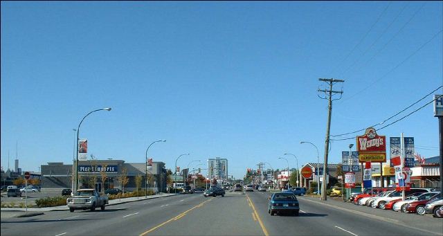
And it won’t just be the airport and connecting routes that generate the traffic; much of it come from the urban form in Abbotsford itself, which looks like this:
.
.
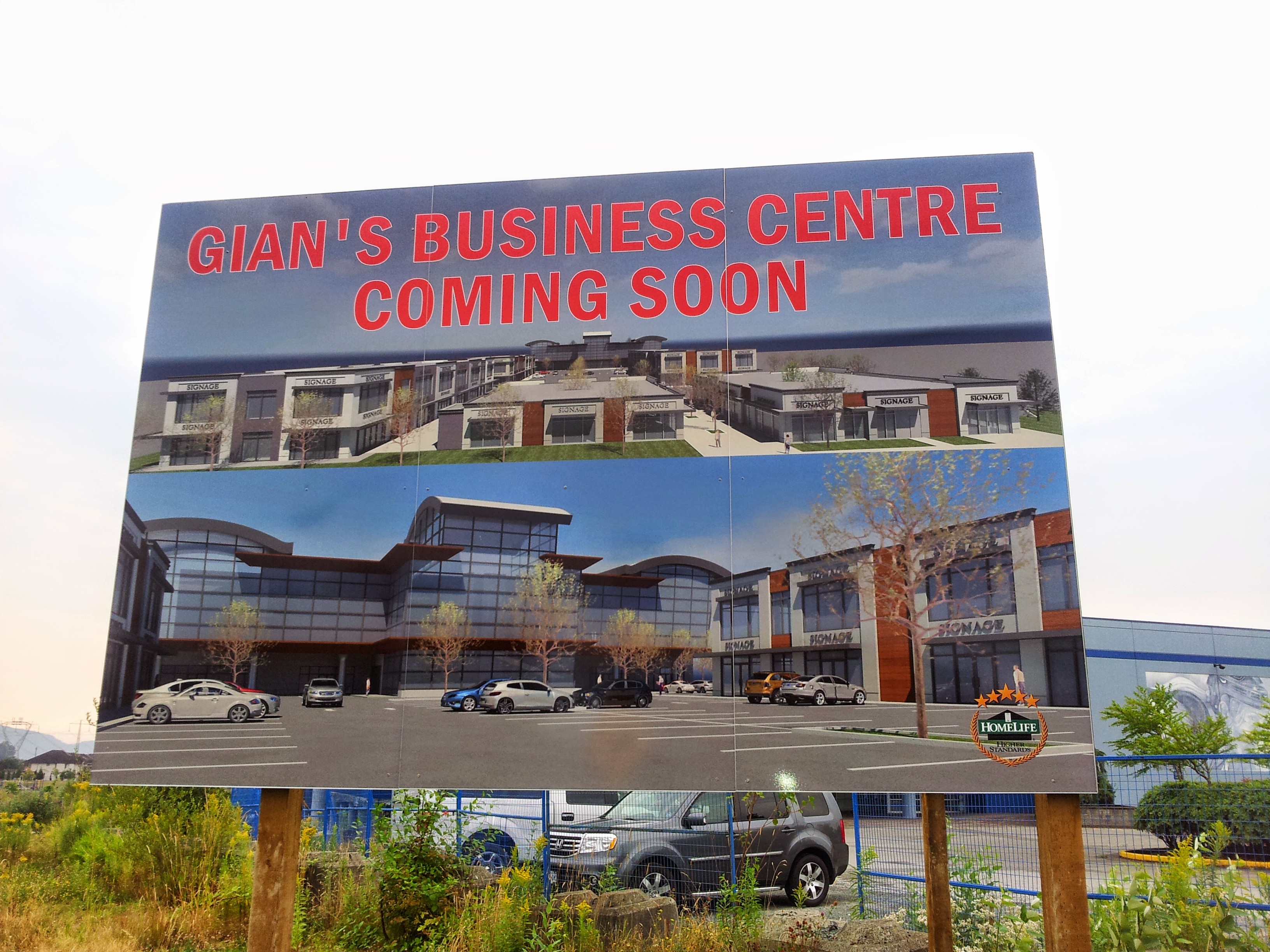
With more to come. Here’s a drawing of the new shopping centre proposed for the Townline Hill section of Abbotsford, sent in by Ken Wuschke: “Essentially it is a parking lot surrounded by retail. Towards the street there will be little connectivity to pedestrians walking by as all the stores have doors facing the parking lot.”
.
Two points to make: this is what is being approved by a municipality whose leaders are loudly critical of the air-quality consequences of Metro Vancouver’s proposed incinerator. And this is the form of development supported by the Province’s infrastructure commitments: bridges, highway-widenings, goods-movement corridors – like the 16th Avenue interchange, and very likely, support for the widening of 16th Avenue itself.
Needless to say: there’ll be no vote on that.


So the idea of trams in the curb lane of South Fraser Way has been forgotten, then?
Presently the City of Abbotsford is working on reviewing and updating their Official Community Plan > http://www.abbotsford.ca/economic_development_and_planning_services/major_initiatives/abbotsfordward_-_official_community_plan_update.htm.
They have consulted a consortium of companies led by Brent Toderian > https://twitter.com/BrentToderian/status/466380716243439616
My understanding is that all neighbourhood plans such as the U-District concept > http://www.abbotsford.ca/economic_development_and_planning_services/major_initiatives/U_District.htm < and long range transit plans are on hold until the OCP process finishes in a years time.
I blogged about Abbotsford’s “comprehensive zoning reform” here: http://midrisemixeduse.tumblr.com/post/90874532227/abbotsford-zoning-reform
In their 21st-century-ready sustainable growth-oriented liveable prosperous new zoning code Abbotsford are choosing to:
– Zone by use
– Mandate minimum parking
– Maintain niche motordom use-zones like “Automall Commercial”
The goals are noble. The method is questionable. Incremental realpolitik of course, but I somehow doubt this will be a shining light of Toderian Urban Works’ resume.
A growing region needs roads, bridges, tunnels AND public transit infrastructure. Of course it is just plain silly to have a referendum on public transit but not roads or bridges !
Ideally this new 16th Ave highway comes with a train track in the middle for a high speed train connecting Abbotsford Airport with YVR and other trains in the MetroVan region.
What train is it suppose to connect to? Burlington Northern isn’t going to want this. Why is someone going to take a train between airports? This makes Zero Sense.
Because airports are major transit nodes, usually reached by car or cab unless a train goes there like YVR, and soon YYZ. To reduce car dependency fast alternatives are required otherwise people will not leave their precious cars.
You said a high speed train connecting YVR and Abbotsford Airport, why would you take a high speed train between 2 airports? Makes no sense.
The only reason would be if a passenger arrived on an Abbotsford domestic flight and needs to transfer to an international flight at YVR – but that would be stupid route planning.
That rings of Dorval = domestic and Mirabel = international.
Stephen, I forgot to mention the Vicarro Ranch proposal.
“The three parcels making up the VRPA consist of approximately 155 hectares (383 acres). The proposed development will occur within five (5) development sub-areas that are generally shown in Figure 4 of Report EDP128-2013, and will allow the development of a combination of single-family lots, duplexes, townhouses and apartment buildings, with a combined maximum density of 1400 residential units. Of the proposed 1400 units, up to 580 are proposed to be single-family lots, 120 are proposed duplexes, 260 are proposed townhouses and 440 are proposed apartment units. In addition to residential development, large tracks of open space, three city parks and a series of trail systems will be secured through the development process. A neighbourhood commercial node is anticipated adjacent to Whatcom Road at the south end of the lands and will provide a variety of local shops and neighbourhood commercial services to the surrounding area. In terms of area under application, and the number of residential units proposed, this is the single largest application proposed in the City of Abbotsford in over a decade.”
http://www.abbotsford.ca/economic_development_and_planning_services/major_initiatives/vicarro_ranch.htm
People in the burbs love their cars … and not having a car in Abbottsford or White Rock is just not practical today. With more public transit eventually that may change, but the only folks without cars there today are either very old, very young or very poor.
and to move beyond shallow stereotypes we might include among those who do not own cars; owners of bicycles, scooters, motorcycles, those who prefer not to own cars for various reasons, those who cannot drive for disability reasons, those who have been banned from driving for various reasons, those who are members of car share programs, those who have friends with cars, those who prefer taxies or limos, those who rent cars on occasion, those who hitchhike, those who prefer to walk, jog, run, skate board or rollerblade. People do not love their cars unless they own a hot rod or a classic car; the rest of humanity readily curses the automobile as can be observed during a traffic jam, at any car repair centre, upon the issuance of a ticket for a parking or a moving offence, upon receipt of an annual insurance invoice. Age or income has nothing to do with car ownership.
not in Abbotsford or White Rock. This is not Vancouver ! Get our more and have a look.
I think it’s more accurate to say that “people in the burbs use their cars”. It’s a necessity only because of the design of the infrastructure intentionally leaving out the usefulness of any other mode.
I know people in the suburbs who would love to see some of the things like sidewalks, cycle paths, underpasses, etc that are in cities appear in their areas too but they usually feel it’s unlikely to happen so just sigh and get in their car to go 5 blocks.
When I lived in the outskirts of town, the bus was pathetic, I could not get a drivers license, I was stuck. I had to be very organized to get a bus. I was often let down by the poor scheduling so was late for things. People need to be given more options.
Back when I worked for the ALC in the early 90’s, the MOT as it was then called had a number of hypothetical highway plans that they shared with us, including a connection between Hwy 1 and 99 through the Serpentine valley, something along 16th and even one along 0 Avenue from Sumas to 99. The notion of completing the connectivity in the freeway system continues to be considered. That said, I have to confess that I love taking the south Fraser Perimeter Road from the ferry terminal to the TCH in Surrey. So much faster for my trips to the Interior from the Island than my previous route of choice along River Road to Scott Road and then 104th through Whalley.
About time the Lower Mainland is investing in better car based connectivity. Hwy 1 is still not 3 lanes to Abbotsford. And yes, we need bike lanes, buses and subways too. But to move 2.5M (soon 4M) people around and to serve 30+ ports in the Lower Mainland one needs decent car/truck infrastructure .. AND bike lanes/subways/buses/skytrains.
S Fraser perimeter road had still 3 or 4 signaled intersections. Why ?
A major 16th Ave road upgrade (with allowance for a future trains) makes total sense to me to alleviate the clogged Hwy 1 east-west and to serve the ports and industrial areas along the Fraser River and its cities.