

From Dan Ross:
Some very sanguine predictions about the future of Moodyville, North Vancouver, in the North Shore News this week.
 Granted, these worldly visions of creating a Little Vienna on the North Shore came from a property developer speaking to the City of North Vancouver Council last Monday. However, this low- and medium-density residential neighbourhood just east of Lonsdale Avenue is slated to undergo some significant changes in the next 20 years.
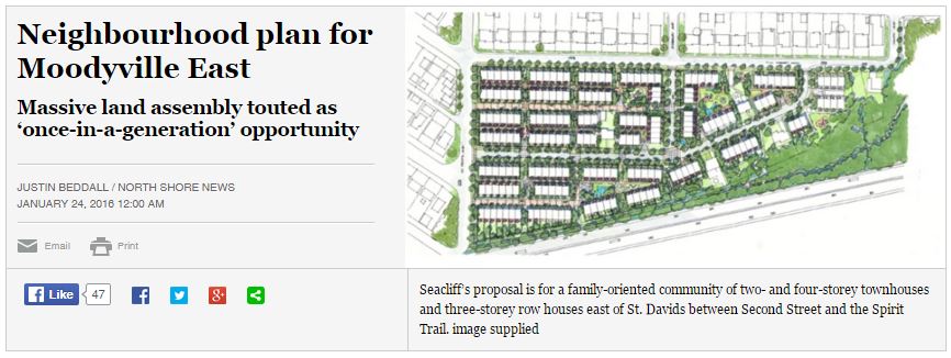
All this jibes with changes made in the 2014 Official Community Plan and Metro Vancouver’s urbanized growth area plan, with the largest densities slated for 3rd Street. There is an old 100-foot right-of-way along this corridor that Council will finally be able to take advantage of. The plans for the proposed zoning are shown here.
.

There are no renderings of this “European-inspired neighbourhood” yet, but judging from the tidy but still very North American-inspired state of the existing neighbourhood , there is a lot of work to do: pensioners to buy out, paths to build, homes to demolish and to erect.

.
This will undoubtedly be a contentious, multi-year process. Another piece to making the North Shore a responsible contributor to the regional growth plan, despite the hoarse cries of my neighbours who swear that we on the shore have already contributed “enough.” Should be fun.
The City of North Vancouver provides more information here.


Perhaps it’s time to start considering running rapid transit to the North Shore? A Skytrain line down East Hastings, through Hastings Park, across the Second Narrows to Phibbs, through Moodyville and up Lonsdale would service areas well oriented for transit along almost the entirety of the alignment. Ending the line at Hwy 1 and Lonsdale could also open up additional options for rapid bus along to West Vancouver or Horseshoe Bay.
If branched off to connect with the M-Line, it could provide a useful backup to the Expo line in case of a failure or long term maintenance.
The span the for the Second Narrows is about the same as the existing Skybridge (335m vs. 340m) so a new bridge may not be price prohibitive. The Skybridge only cost $28M when it was originally constructed, so any new bridge likely isn’t all that much more expensive than some of the options considered for improving Hwy #1 in that area. There may also be the option of adding some kind of reinforcement and a lower deck to the existing Ironworker’s Bridge.
What do you think Council has in mind for that 100′ right of way?
Long-term: cars, transit (bus or light rail), walking and perhaps cycling. Cycling was presented as an option only during public input. Another option was to keep all on-street parking.
When looking at the commitment to density by the CNV, notably the increasingly pleasing mixed-use community in the relatively level Central Lonsdale neighbourhood and fairly large-scale proposals like Moodyville, one has to wonder about the future of transit there.
Urbinflux has a good suggestion regarding SkyTrain, and has connected the dots to the Hastings corridor, which was the first corridor originally considered for rapid transit, so I was told 20+ years ago. There may be some value in considering extending the line east of Hastings Park through (yes, through) Burnaby Mountain to serve SFU and connect with the Evergreen Line at Burquitlam on the other side.
There may also be some justification to extending SkyTrain from Lonsdale west to Park Royal, then loop up over First Narrows on a separate bridge to downtown, but tunneled under Stanley Park. How it connects to Waterfront Station would be a challenge at Hastings x Granville, which is within the perimeter of the underground station box of the Canada Line. Swinging up to Pender may be one option even though it will be a bit of a walk to Waterfront, and swinging back tio hastings would be problematic with all the large building foundations. Deep boring under the CL station box may also be an option, and keeps the alignment on Hastings, but that would be a long escalator ride.
The (CN?) freight mainline appears to run under Esplanade between St George and Chesterfield and it doesn’t take a huge amount of imagination to visualize a central North Vancouver Station at Esplanade x Lonsdale (with underground platforms) that connects an intercity commuter rail service (Squamish / Whistler / Pemberton express, and long distance runs up the Caribou to Prince George) and local SkyTrain service to the Seabus. By then a third Seabus should be up and running.
The expenditures would be very large, but if phased over two decades and partial cost recovery was explored with adjacent new development that would directly benefit from improved rail transit, then I suggest it’s all within the realm of possibility/. This is especially relevant considering the vast sums readily spent on freeways and bridges lately without one iota of information on cost recovery, while transit always has a very significant and permanent cost recovery through ongoing ticket and farebox revenue streams.
Here’s the alignment I’ve been playing with.
http://i291.photobucket.com/albums/ll318/Moocowsia/T%20Line.png
The orange section or Metrotown section could be used to divert Expo trains.The branch in Burnaby runs along Willingdon. Everything could be build picecemeal though.
Putting aside the fancy technological choice, your map is interesting since it is effectively highlighting important transit corridors (and Translink is moving forward on some like the Hasting one, albeit with more efficient bus operation)
More interesting, is the orange segment, Commercial Drive, connecting the Expo line with the Hasting corridor in the most effective way: a recognition of its structuring role in the Vancouver Transit Network (something the Mayor plan was also somewhat recognizing with a B line on Commercial): It needs to be there: a simple question of geometry.
That raises the question:
How can we have a bike lane on Commercial without compromising the Transit network integrity?
in 2015 some was advocating for more Translink tax $ which could have been devoted in part to a B line on Commercial.
Now, in 2016, the same seem to advocate for bike lanes at the expense of better bus service (this to not compromise the all more important car parking)
If that is true, that is nothing short of hypocrite (and they incidentally give reason to the No side in the referendum).
Regarding the referendum, I think people should be prepared to more “direct democracy” (or accountability) in tax matter: that is the direction everywhere: https://voony.wordpress.com/2016/01/11/transit-referendum-policy-some-thoughts/
Beside it, there is already money to expand the bus fleet: it is up to the municipality to increase the property tax (and/or provide bus lane or other measure able to improve transit efficiency…) to enable Translink to put more buses on the road.
Author
People, people – the transit referendum lost. And it’s the law, says the Premier, that there would have to be another one, and another one, just to expand the bus fleet. In this world, the projects above have little chance of even being put on a wish list. (That’s only for MOTI projects like the Sunshine Coast Connector.)
It does no help to pretend otherwise.
… how long till that next election again? (ugh)
That sounds pretty pessimistic Gord. The easiest thing I think would precipitate this kind of project is big maintenance on the initial Expo segments. If they ever need to replace a precast segment to two, then lots of people will be very upset and money will move quickly.
Then again I’m only 28, so maybe I’m looking at a longer timeline. But hey, the ~7 year cycle with Skytrain has been fairly consistent across 3 provincial governments.
I will never accept such a flawed process (the plebiscite) as the law when the federal government is providing plebiscite-free funding for transit and there is a viable provincial opposition waiting in the wings with no known history or expressed desire to govern by referenda instead of electoral mandates.
I doubt anywhere in Vienna is as noisy or dusty as East Moodyville. It is too bad that no government had the foresight to establish a park and forest buffer with the recent construction of Low Level Road. I would have thought the City of North Vancouver had the vision, and the federal government the funding to purchase at least one street to make up for the health impact and risk from increased industrial activity and port trade.
I understand the only reason for houses being so close to the grain elevators is that Moodyville was the first European settlement on the North Shore for the Moodyville sawmill. This was long before the shore was industrialized.
Here is a letter to the editor in response to the article above.
http://www.nsnews.com/opinion/letters/letter-grain-terminal-concerns-aired-1.2162485
Vienna certainly used to … Less so now but there were definitely some pretty heavy industries going on.
The thing is, most European cities have had their industries move away from their inner-city ports. This is not something that is being considered here yet. So the only difference is inertia … We have more of it.