
A work in progress from Aaron Licker,
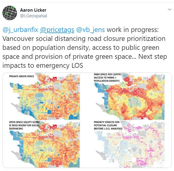
By taking available data on population density overlaid with access to public and private green space, he’s come up with a map that shows where we need ‘flow streets’ – local neighbourhood and commercial streets where additional space is required for sufficient social distance by walkers and cyclists as well as opportunities to recreate with a minimum of conflict with vehicles.

 Note that this is not ‘road closure’, neither when vehicles are prohibited or limited. The streets are still open, just more safely, for a variety of users.
That’s why I call them flow streets: a network of paths, greenways, bikeways, limited-access or local-traffic roads that allow the ‘flow’ of people to be maintained without having to crowd. On routes like the Beach Avenue Flow Way, the three or four lanes of abundant space with room to pass allows cyclists at all different speeds to maintain a comfortable pace – hence a sense of flow. See video here: BAFW.
Next step: name the specific streets for a flow network, whether from Hastings in the DTES or Fraser in Sunset, whether already part of the greenway-bikeway network, like Comox in the West End or 59th Avenue in Fraserview. This expanded network aligns with both our pre-Covid priorities and the needs we face today.





Oh, man, these people who do GIS analyses for fun. Bless them.
Interesting analysis.
Building on Gord’s question about what streets could be selected to create a network, beyond simply calming or reallocating lanes within specific blocks, the issues of connectivity and destinations arise. Look at the map for Chinatown, and Olympic Village, both areas with a fair amount of people walking and cycling. There is nothing connecting them apart from a path in front of Science World. Quebec doesn’t show as a priority, presumably because it is right next to Creekside Park. Similarly, the Cambie and Granville Bridges don’t show up as priorities, but they provide essential connections. Cornwall only shows as a priority west of Balsam, presumably since Kits Park is there to that point. But with the park closed to people on bikes, Cornwall becomes essential. Beach doesn’t show as a priority, presumably because there is a park adjacent, but it was and remains a priority for connectivity. Kent doesn’t show as a priority, but would make a great addition to the south side of the City in terms of reallocating road space, in order to connect neighbourhoods along the river.