
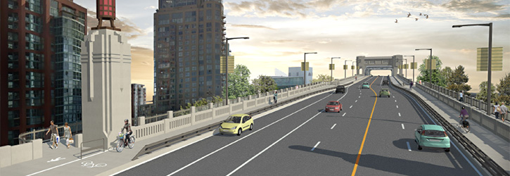
The City of Vancouver just posted an announcement of the proposed changes to the north end of the Burrard Bridge (including a reallocation and extension of space on the entire east side of the bridge):
.
.
Details here, with annotations for this map:

.

.
Media Coverage
.
After the news conference this morning, PT will post media coverage updates here. (Please send in links to any I may have missed.)
From Metro: City eyes eliminating another Burrard Bridge car lane
From CKNW: Vancouver mulls removing another vehicle lane on Burrard Bridge
From News1130: City of Vancouver considering a plan to remove another lane of traffic on the Burrard Bridge
From The Province: Is the Burrard Bridge about to lose another vehicle lane? (Video here.)
From The Sun: Proposed Burrard Bridge upgrade would eliminate one vehicle lane. (Update here.)
From Vancity Buzz: Burrard Bridge about to get better for walking and cycling
From Georgia Straight: City of Vancouver will reveal plans to upgrade Burrard Bridge and possibly remove a motor-vehicle lane
From Vancouver Courier: Vancouver calls for $30 million fix to Burrard Bridge.
From CBC: Burrard Bridge repairs could include improved bike lanes and sidewalks
From CTV: City unveils plan to revamp Burrard Street Bridge
From The Province: Reducing Burrard Bridge’s vehicle lanes will improve traffic flow, city says
.
Open House
Burrard Bridge and Pacific Street Intersection Upgrades open house
Drop-by anytime during the event to meet the project team, give feedback about the proposal, and ask questions.
June 6 2015, 10:00 a.m. to 2:00 p.m.
Roundhouse Community Arts and Recreation Centre, 181 Roundhouse Mews
.
If you are unable to attend an open house, complete this online survey.


That will be good to give the east sidewalk back to the pedestrians. Banning peds from the east side of the bridge never really worked anyway.
Bike +1
Bus:
https://voony.files.wordpress.com/2013/10/bus22burrardpacific.jpg
It uses to be a time when you were able to access Transit at Burrard#Pacific.
Today you have to do the Hike to Burnaby…
but even that is now compromised: the plan gratuitously call for ever worse for the transit users. The city’s war on buses continues.
The City always make sure Transit becomes more and more expensive to operate and less and less attractive on every single project they implement….A city which is never ashamed to ask folk to fork more money to pour on Transit…
Isn’t that a restored transit stop marked on the map with annotation 15 on Burrard at Pacific?
Just to be clear, when you say “hike”, you mean walk 150 m on a sidewalk, right?
What do you think is appropriate spacing between bus stops?
The well accepted number for the coverage of a bus stop is a 1/4mile radius or so (can be lower due to terrain)
Save for the bus C21: Most of the DownTown area south of Pacific is out of reach of Transit without a bus stop at Pacific.
Then there is the matter of bus connectivity: commending bus stop both at Davie and Pacific (closest point toward bus C21)
If you are saying they should move the bus stop from Burnaby to Pacific, I agree with you.
If you are saying they should have both, I disagree.
Jeff, I suddenly remember the conversation we had at the Waterfront station pub: you are a well informed guy ;)>/em>
the bus stop marked (15) is already existing: the proposal is too maintain it !
I talk about the bus stop for bus going south bound: It misses a south bound bus stop at Pacific#burrard intersection, which has been supr0essed in the previous round of “improvement” (the one I pictured). so people has to go to the bus stop annoted (9) which is proposed to be relocated ever farther away from Pacific.
Yes: The bus stop southbound should be restored at Burrard#Pacific. The welcome removal of the landscaped barrier on Burrard allow for a bus stop as below:
http://www.fietsberaad.nl/library/repository/ontwerpvoorbeelden/rs_6%20Kopenhagen,%20groene%20golf%20voor%20fietsers.jpg
…and in fact, all Burrard should be treated on this model
Good point on southbound. What would you give up to achieve that transit stop? A vehicle lane? Or instead the boarding area for the bus (boarding from the bike lane, as per your photo)? That seems risky for pedestrians given habits of local.users, and not just cyclists.
As per the photo, incidentally, I notice that could also be the preference of Jarret walker, of course for good reason> as he states, it is not perfect, but it is eventually the less worst of the solutions and there is no reason it doesn’t work here (it works in cities as diverse as Toronto or Amsterdam)
That said, a floating island could work as well here, especially if the southbound bus stop is located on the south side of the intersection where there is ample room for it.
More take here: https://voony.wordpress.com/2015/06/02/burrard-bridge-the-war-on-transit-continues/
That intersection is horrible and dangerous, and normalizing it has been considered since the c. 2000 Downtown Transportation Plan. Long overdue. And restoring pedestrian use to the east side is also wonderful. Much better than the wild and very costly ideas previously considered, like outriggers and something suspended below the bridge.
My question is, will the existing (excess) capacity on the Granville Bridge now need to be protected for possible traffic diversion, or not? If yes, what does this say about the proposed Greenway down that bridge’s centre, of which we have heard nothing for far too long? I would have expected a feasibility study and conceptual design there to be easier to complete than, say, a similar one about removing the viaducts.
I’m really impressed with what the city is proposing here. This really looks like a win-win-win for all three modes, even cars!
Never have I driven north over the bridge and had to wait more than one traffic light cycle at Pacific. So three lane capacity is really overkill. But there is often a back up trying to turn east onto Pacific, so creating two right turn lanes is a huge improvement. Same goes for right turns off Pacific heading south over the bridge.
Regarding the right turns off Pacific heading south over the brige, the city should run some ads on the North Shore explaining how to get to Kits without using Pacific (use Howe/Granville bridge). A lot of traffic on Pacific is from the North Shore as people cut through the West End or Thurlow to get to Burrard. Sometimes the causeway is closed in the morning rush hour due to a collision. No backups or hardly any traffic on Pacific then.
I like the elimination of the slip lanes. Note the proposed widening of Burrard and addition of additional turn lanes for cars where there are currently some delays getting on and off the bridge. Also looking forward to a northbound bike lane on the bridge that is wide enough for passing.
When are they going to do something similar for Granville and Cambie bridges??? Or is this the start of consultations for the other bridges. If so then I am super happy.
Both have been said to be in the plan.. Write mayor and council and let them know how you feel.
Nice to see them reinstate two pedestrian sidewalks and the Pacific bike issue finally resolved (which has been dicey for both cyclists and drivers through those 2 blocks).
The key to the north end improvements is the double right turn lanes to Pacific and the widening of Pacific on the former Kettle of Fish block.
It also looks like the bridge itself will be widened – but not so far along as to interfere with the heritage aspects of the towers.
I assume that the City has analysed the south end double right turn lanes and will be applying that knowledge to two double lane right turn movements
– northbound Burrard to eastbound Pacific, and
– eastbound Pacific to southbound Burrard.
Given the extra timing required for the eastbound Pacific to southbound Burrard, I am very surprised that they have not reinstated a right turn from southbound Burrard to westbound Pacific. That movement could coincide with the aforementioned movement, as bikes would have to be stopped for that cycle. It would eliminate the “point of no return” aspect of heading south on Burrard.
One other comment is that they should lengthen the right turn lane on eastbound Pacifc to southbound Howe. There are a lot of right turns at that corner, and if there’s a dedicated right turn signal that will back-up traffic and if there isn’t a dedicated right turn signal, pedestrian traffic (blocking right hand turns) will increase with the Vancouver House Tower, grocery store, etc. slated to be built nearby.
It’s a really good design. The current situation is bad and needed fixing. I hope it’s as well designed as the south end. That works very well now.
Guest – whoa. Is the bridge to be widened? Where can that info be found? Does this mean the outrigger concept is back on the table? I sure hope not.
Yes – wider bridge on the 100 yards at the north end, both sides. See the detailed drawings and cross-sections available at CoV web site.
Looking at the plan I see that additions outside the concrete fence are only in the very northern end of the bridge. About over Beach Avenue. Hopefully they’ll be in keeping with the style of the bridge.
Love the addition of the curb extensions at various places along Pacific. Especially the sw corner of Pacific and Hornby that I always have trouble navigating with my 5yo. I am assuming that that would force ‘no turn on red’ signs, although drivers generally seem challenged with reading comprehension when faced with such signage. And the connecting Hornby along Pacific back to Burrard southbound is great, right now getting back on the bridge with kids poses some challenges. The existing connection along Drake and Burrard is doable but not exactly low-stress.
This is a great proposal. I’m especially excited about reinstating space for pedestrians on the east sidewalk of the bridge.
Also, I can’t help but notice that all of the mainstream media sources use headlines bemoaning the loss of a vehicle lane; only Vancity Buzz is taking a positive spin and touting the improvements for walkers and cyclists.
And I bet none of them are going to even mention all the improvements for motorists.