
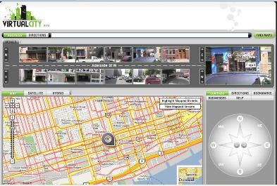
If you like Google Earth, you’ll love VirtualCity – a pedestrian view of Toronto (or at least a good portion of the central city). This beta version allows you to see streetscapes lot by lot, image by image, with a very user-friendly interface. Check it out. If you’re knowledgeable about TO, expect to spend some time.


It’s wonderful but it’s yet another case of Toronto envy. Any thoughts from the multitude on how can we nudge a Vancouver version of VirtualCity into being?
Not so fast. VirtualCity has also mapped out Montreal’s streets, even though it’s not obvious at first glance. Perhaps with a bit of luck Vancouver won’t be far behind.