
Sea rise, water infiltration and flooding is nothing unexpected-it was UBC’s Kees Lokman who has been insisting that every municipality have one specific person on staff to deal with coastal issues and stormwater management. Last Spring Viewpoint Vancouver wrote that the most fertile farmland in Canada is located along the Fraser River and that one-third would be impacted by flooding, threatening food security. We also mentioned that some flooding (as we just experience in Vancouver) at high tides would be in areas that would be permanently underwater by 2050.

You can take a look at the research creating the open-source data base Living with Water created by Mr. Lokman. Even though we know that the sea rise of one half a meter is expected by 2050 and a sea rise of one meter expected by 2100, we still build on low land and plan more tall buildings on flood prone lands like it is 1999. Most of people in the province live close to water, with sixty percent living in Metro Vancouver.
One of the founding fathers of British Columbia’s Agricultural Land Reserve (ALR) and City Councillor of Richmond Harold Steves puts it this way on social media: “why build cities on floodplains? Because farmland and wetland is cheaper to buy and build on than upland, without regard for the future. That’s what I said in 1959 after Richmond B.C. rezoned 12,000 acres of farmland and put my father and a thousand other farmers out of business. Save the ALR”.

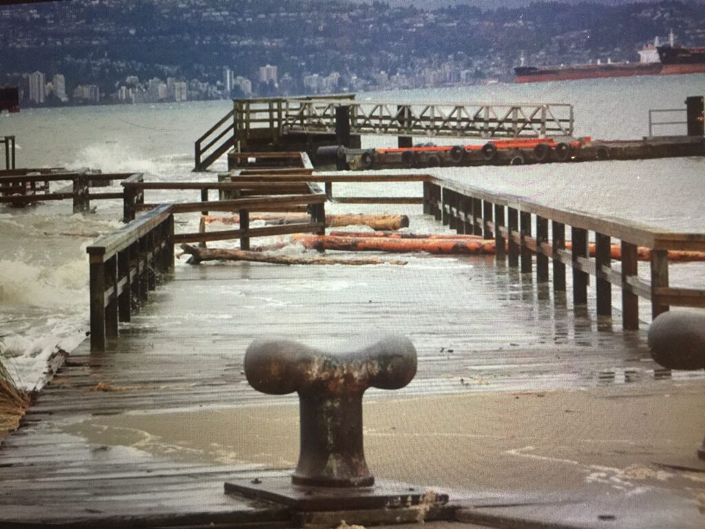
Combine the highest tides of the year with gale force winds and you get the kind of damage people saw in Vancouver on the weekend, with the Jericho Pier broken and the Stanley Park’s iconic seawall picked apart like pieces of gingerbread. The worst damage occurs when coastal flooding, erosion coincide with storm waves and high peak tides.
From an engineering perspective the seawall is repairable but does require materials and labour to get the job done. While some media gloomily suggest that the seawall is finished, it is not. Just like dedicated bike lanes and sidewalk amenities the sea wall will be rebuilt. We are not far from having different technologies that will be able to sling and hammock walkways in ways that can be protected from erosion in climatic events.
But that does not address what is still not seen as a regional pressing challenge that needs immediate focus. The Fraser Basin Council has a draft Lower Mainland Flood Management Strategy that estimates future flooding will result in 20 to 30 billion dollars of economic loss. Metro Vancouver has had significant floods, in 1948 and in 2021. The report notes that regional development has been growing on flood plain hazard areas , putting at risk these areas and the critical infrastructure that supports them.
Mr. Steves notes that a one foot sea rise would jeopardize the City of Richmond’s dyke system. The dredging and channel deepening which has been done along the Fraser River also exacerbates flooding. Still we are looking at building a new hospital precinct and new development along Vancouver’s shoreline and in False Creek.
There is a lot we can learn from the Dutch about water management. In 1953 a horrendous flood resulting from a storm surge along the North sea killed 1,800 people. From that disaster the country developed a comprehensive management system of “polders”, which are reclaimed land parcels that would normally be below the sea. Instead of physical man made dikes protected and bolstered dunes double as water protection for communities and wonderful natural bird habitat. Experts are modelling out ways to compensate for a potential 84 centimeters of sea rise by 2100. (Vancouver’s sea rise is predicted to be one meter by 2100.)
Sadly as a region we just are not there yet.


Nice job, Sandy.
But don’t look down.
https://www.rollingstone.com/politics/politics-features/doomsday-glacier-thwaites-antarctica-climate-crisis-1273841/
This is the scariest story I’ve read on this topic. It predicts, based on some serious data, that all bets are off for all coastal areas in the world in five years.
I believe that the prediction of less than 1 meter rise by 2100 may be an acceptable prediction, but not a basis for planning a society that will last. It is wishful thinking.
We need the kind of planning we put into earthquake preparedness for bridges etc. We plan and build for the a bad event, and then hope for the best.
This calls our leaders to pay attention to unfunded liability and time horizon. It calls for making difficult decisions about land use, and sustainable population size.
I spent time in 2019 researching sea level rise and the research was not encouraging:
1)The game changer now is the modelling from new remote sending buoys which sink down and measure temperature etc. in different levels of the oceans around Antarctica and then surface and send data out. The NYTimes has produced a excellent piece on this:
Rising From the Antarctic, a Climate Alarm 18Dec21
Wilder winds are altering currents. The sea is releasing carbon dioxide. Ice is melting from below. By HENRY FOUNTAIN and JEREMY WHITE
https://www.nytimes.com/interactive/2021/12/13/climate/antarctic-climate-change.html?campaign_id=54&emc=edit_clim_20211215&instance_id=47902&nl=climate-fwd%3A®i_id=68483755&segment_id=77090&te=1&user_id=235814f2f162ec9aba56799a253ae907
I might add that in addition, there are many reports of significant sea level rise in the historical record- and the present warming is much faster than earlier ones.
I believe the article above implies that timelines are likely to be shorter than the estimations in the following articles.
Here are some excerpts and links for those interested with estimates of sea level rise:
2) “glaciers in the Amundsen Sea sector showed that its collapse is underway, and that the rest of West Antarctica will follow. While one of the studies said the demise could take 200 to 1,000 years, depending on how rapidly the ocean heats up, both studies concurred that the collapse is unstoppable and will add up to 12 feet (4 meters) of sea level rise.”
https://climate.nasa.gov/news/2328/warming-seas-and-melting-ice-sheets/
3) Ocean rise of 2.5 meters but un-reversable.
https://www.theguardian.com/environment/2020/sep/23/melting-antarctic-ice-will-raise-sea-level-by-25-metres-even-if-paris-climate-goals-are-met-study-finds
4) In the latest National Climate Assessment, issued in 2018, 13 federal science agencies called the need to retreat from parts of the coast “unavoidable” in “all but the very lowest sea level rise projections.”
https://www.nytimes.com/2020/08/26/climate/flooding-relocation-managed-retreat.html
There are many more academic articles, especially on historical sea level rise, but I’ve just included the more approachable articles.
If you want to dig into the academic articles, one place to start is to search for this article and check out the authors of the references:
5) Oceanic forcing of penultimate deglacial and last interglacial sea-level rise
..understanding why LIG (Last Interglacial Age) global mean sea level may have been six to nine metres higher than today….
Sadly, the predicted rise may turn out to be a very low figure because one of the world’s largest glaciers, the Thwaites Glacier, in Antarctica has started to break free of the continental ice sheet and the probability is that it will slide forward into the ocean resulting in a 2 metre rise in sea level. Some high degree of proactive planning is essential to avoid catastrophic flooding as happened to the Netherlands. That same storm surge also hit London and I recall many drownings but not on the same scale as Holland. A dozen years later the funding approved to raise the Thames Embankment in London and build diking downstream along with the Thames Barrier Gates which has been deployed many times since. The notion of building similar gates at Burrard has been dismissed. While protecting the most expensive real estate around False Creek would be good value for money the ALR of Richmond, Surrey and Delta deserve attention before incremental rising of saline seawater renders soil for crop production as non viable. Building a dike can protect against flooding but will not stop saltwater intrusion unless engineered with a deeper clay curtain.
Flood mitigation at this time for the seriously flooded areas/agricultural lands in Abbotsford will take several years. I realize this blog is about Metro Vancouver. However this region depends directly and heavily for local fruit and vegetables (if U.S. shipments are a 2nd choice, ec.) and rest of Lower Mainland…plus Alberta folks. (We get blueberries shipped from same region summer to fall if we get Canadian produce. Alberta can’t grow blueberries nor raspberries) Hence, the 2021 flood damage is far-reaching.
As for flood mitigation along Vancouver’s shorelines sounds like multi-year projects.
I live in Calgary’s flood plain near the Bow River…. I was 1 of 100,000 residents who were evacuated when the River overflowed in Calgary in June. 2013. The flood damaged clean-up of homes, land was for months. Every single year since 2013, in our area there is a flood mitigation construction project.
That’s going on..for the past almost 10 years since mitigation has been a series of different projects for each different location involving different infrastructure on both sides of the river banks. The Bow-Elbow River flows from north of Lake Louise with glacier, through Banff, Canmore (flooded also) and snow melt into Calgary.
https://cyclewriteblog.wordpress.com/2013/09/03/major-flood-or-disaster-do-transportation-habits-change/