
In the next few years, the City will be constructing the Granville Bridge Connector – a safe and seamless route for everyone not in a car or bus that, as a side benefit, will revitalize the southern end of the downtown stretch of Granville Street.
But best of all will be another piece of the greenway network and the end of what, as Pete Fry noted, is the most terrifying cycling experience in the city. For pedestrians, the same:

Even getting on to the bridge deck is intimidating – a totally unacceptable design in this city:

Not only will that change, but the opportunity to appreciate the stunning views of the creek and skyline will make the bridge a choice that to date most of us have avoided. And in the last few years, the views have changed as construction in Downtown South has significantly altered the skyline – so much so, that the district from Burrard to Yaletown, south of Davie, needs its own name.
How about G’Ville?
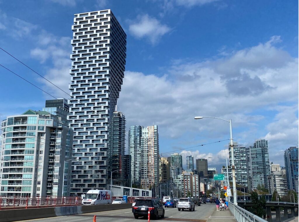
Here are a few shots I took when walking my bike across the bridge (no, I wasn’t going to cycle that sucker). The biggest change of course has been Vancouver House, and a few its new neighbourhours north of Pacific.

The boxy black tower on the left is The Pacific from Grosvenor – the likes of which we haven’t seen since the TD Tower, visible on the right, from 1972. (It in fact was the reason we haven’t seen anything like it since, so negative was the public reaction.)
The pavilions at the base of Vancouver House come from the Shard School of Architecture, with some patches of wild green:


 Together, they’ve already created the sense of a gateway into the core – but there’s more to come. Vancouver House, with its arch effect (see above), effectively provides the west side of the gate, and here’s what’s coming for the east side at 601 Beach (right). The combo will be another of those ‘postcard’ shots suitable for backdrops on TV when the name of the city isn’t even needed.
Since the new tower will block some of the views of the city behind (and the connector will be on the opposite side of the bridge in any event), this view of G’Ville is temporary:

It’s about the only place on the north shore of the creek where there’s enough colour in the architecture (with help from the social housing) to provide a break from the glassy greenness of Vancouverism. Otherwise, it would just be more of this:

But thankfully, there’s also the variations that come with the deep blue of the creek and the dark greens of the urban forest – now in its third decade since much of it was originally planted in the ’90s and early 2000s:

Once the existing lots have been built out, the bike network completed and the street trees planted, the next big changes will come when the cloverleaf ramps of the bridge are demolished, the lots squared out, and another set of towers will be tucked into the fabric of G’Ville.


The boxy black tower (The Pacific), which is not black on all sides, looks sleek now in today’s mess of green (what?!) cluttery, tacky stack of windows. From a farther distance, the best looking buildings are the Wall Centre because their blue colour melds beautifully with the sky, becoming near invisible.
The Squamish people , who lived in the village of Senakw opposite, most likely had a name for the land we now call Vancouver. Why don’t we ask them? Of course GordonVille, colloquially shortened to G’Ville has merit for inclusion as well. 😉
The Granville connector will cost $50M or more. No cost sharing from seniors govts, ( TransLink contributing around $5.276M ) A new Pedestrian Cycle Bridge could be build like other big Canadian Cities and Senior govts would cost share the new bridge.
We need to complete the Cambie Bridge by matching the west side cycle/walk with the east side.
Burrard Bridge was build with a design that allows a lower deck ( for Streetcars in the 1930s ) We could add this lower deck now for cycle/walk.
Why spend $50M on an old Granville Bridge ?
It’s not the bridge itself that’s the major headache. It’s the approaches. Those expenses will not change with a lower deck or new bridge alignment.
Hey Gordon, I cycled the G’ville bridge (N to S) a couple of weeks ago, using the Fir st off ramp. Wasn’t too bad a ride particularly since I could hide away from traffic in the construction lane. But the new version should be a big improvement!
When I lived in upper Kits (8th and Arbutus), that was my regular cycling route to work, as I kept my elevation. However, S-N I used the Hemlock onramp and Seymour offramp to eliminate lane crossings which can be terrifying. Southbound, I used Howe (which has a bad pinch point at the top and the Fir offramp as with the downhill, I had enough speed (~40 km/h) to easily make that crossing. So for me, the bridge was not terrifying, expect for a few idiots who passed far too closely. I’ve found there are many streets that are much worse to cycle on.
However, for pedestrians, it is awful with the narrow, high sidewalks and the multi-lane crosswalks were most drivers don’t stop.
That all being said, I’m looking forward to the changes, as they will make it a lot better for vulnerable road users.