

Facing Cambie, near 45th Ave., it looks like a motorboat to me. Thanks to Henriquez Partners Architects.
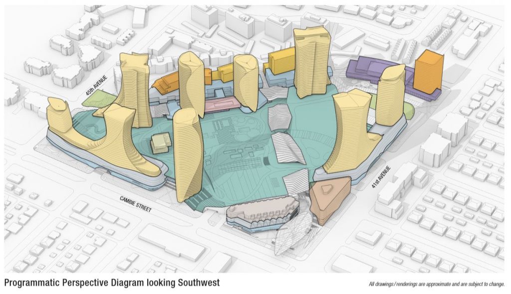
A bold-looking mixed-use Oakridge Centre is rising in the city, on 28 acres, at the site of a Canada Line transit station. Henriquez Partners Architects have designed something that is billed as the largest development in Vancouver’s history. Completion date looks to be 2025, costs somewhere around $5B, with 2,548 new residential units, and two 40+ storey towers among 12 other buildings. And it’s right in the middle of a predominantly single-family residential area, with rising density nearby.
Part of the design rationale is, however, specifically to generate density at an important transit hub. Mission accomplished, it seems to me.
Of the 1,965 market housing units, 84% will be 2 or 3 bedrooms. Of the 580 rental and social units, 249 (43%) will be 2 or 3 bedrooms.
It’s a good example of transit-oriented, mixed retail, residential and commercial development, including 9 acres of park space, and a reminder of something similar underway at Richmond’s venerable Lansdowne Centre Mall.
Oakridge, like Lansdowne, is yet another role model for the much bigger but still mysterious Jericho development (90+ acres), which has land, a terrific location, but no rapid transit yet.
See previous Price Tags coverage HERE, HERE, and project data HERE. And more renderings HERE (with thanks to Peter Meiszner at UrbanYVR).

From Development Permit Project Data PDF (link above).
To quote the Architects:
Working with QuadReal and developer Westbank, Henriquez Partners is acting as the Project Master Plan and Residential Design lead, working with Interior Designers WonderWall, Retail Architect Gensler, and Executive Architects Adamson Associates.
The redeveloped Oakridge Centre includes varied residential housing that will cater to families and seniors. The development includes 290 rental units, 290 affordable housing units plus traditional market housing options. Residential use amounts to nearly 2.76 million square feet, 20% of which will be affordable units.
Alongside residential use, the new development will also include retail (double the current size), office space, and 100,000 square feet of civic amenities including a library, a community centre and a daycare. A 9-acre community park is also part of the vision, plus a network of pedestrian pathways across the development (over 5 acres) that will link these components—promoting walkability while creating opportunities for meaningful community interaction. The Oakridge Centre development aims to set new precedents for social, cultural, economic, and environmental sustainability.
Building on the success of the adjacent Canada Line SkyTrain, Oakridge will explore alternative transportation solutions such as car co-ops, bike and car valets, bike and car shares, and reduced parking ratios.
Parking is always an interesting topic, since it uses up a whole lot of space, and is an enabler of behaviour. The shiny new Oakridge will have 4,783 personal motor vehicle spaces, with 1,550 for the 2,548 residential units (0.6 per unit) and 2,381 for retail customers and presumably, employees. Offices & civic centre — 852.
Bicycles? Glad you asked: 3,185 spaces for residential bike parking (1.25 per unit).
Clearly, the new Oakridge is anticipating walking, cycling, transit and car-sharing for it’s population of residents, shoppers and workers. Multi-modal people in a multi-modal city, in other words, with many choices of ways and means when it comes to travel.
The new development replaces a squat, ancient, car-oriented shopping mall that dates from around 1956. Old Oakridge is mostly one-story with a parking lot on top, surrounded by a giant parking lot, two small towers, and at least two levels of parking beneath. Ya know, cars, cars, cars. They’re what space is for. And they’re the one and only travel mode.
Meanwhile, this sort of 6-decade-old thinking, being repudiated via teardowns and redevelopments, seems to have fled to the land that time forgot, where has risen that dusty old clone-of-ye-olde-Oakridge, Tsawassen Mills. It’s a sprawling mall in a sea of asphalt (6,000 parking places), and it has earned LEED Core Shell status, leaving me baffled as to how that is possible, unless of course your vision is narrowed, blinkered and myopic to a truly remarkable extent.


Looks awesome and is the right thing to do for a high growth international city of world scale.
Yet the transit system is already full. Where is the corresponding expansion of the Canada Line stations with longer trains / longer platforms AND the UBC subway/LRT loop that loops back from UBC via 41st Ave to connect with Canada Line and SkyTrain in Burnaby?
I am befuddled that these massive developments do not consider transit impact onto an already very strained system. A complete failure of governance on the city and provincial level.
These projects have the potential to reduce demand on transit. It remains to be seen if they will achieve that. But if you balance housing, jobs and recreational activity there’s no good reason that a large percentage of people working there could live there and take advantage of other local amenities built right in.
I don’t believe a major project like this built along a rapid transit line has ever reduced transit demand. Even if people take advantage of amenities within walking distance, they’re going to have friends come over, they’re going to commute (especially families with two working partners), they’re going to go out, etc. Just as roads induce demand, so too does transit induce demand.
If that’s true then Thomas’s call for more transit will just induce more demand. Is it the development or the transit that increases demand?
If friends come to visit or they go out it will likely be at non-peak times so no need to increase peak load capacity. Maybe one person in a couple will commute. Maybe the other will work on site. Maybe both. More likely than now with more jobs nearby.
Hmmm, let’s see…
there are 24 new Canada Line cars coming under the Ten Year Vision.
(I think there are currently only 20 Canada Line cars)
https://tenyearvision.translink.ca/
Given the extreme weakening of the market over the the last couple months, I’ll be very surprised if they are in a hurry to break ground on this.
WRT LEED and the mall –
I would expect that LEED evaluates the project as built, without delving into whether or not the project is desirable or not from a sustainability perspective.
Likewise, if single family houses are assigned LEED points, those are a very inefficient use of land for housing the masses (even if they have the latest and greatest whiz bang enviro features) since they ultimately force more development further away from the city core. If you’re going to examine whether the mall project is a sustainable form in the long term (100+ years), there should also be a similar outcry for granting LEED points to single family houses.
Wow. Meanwhile on the North Shore anything over two stories brings out the “Just Like MetroTown!” brigade, foaming at the mouth about GridLock and the lack of services. It really is astonishing how strongly some people feel about maintaining the 1950s single-family home paradigm, and the “cars are everything” attitudes that lead to thousands upon thousands of parking spaces at the expense of anything else.
I think it looks nice. I especially like that it appears not to have roads cutting through it (at Brentwood we will be cursed with 3- and 4-lane streets interfering with pedestrians – streets designed by the city, amusingly enough, for “cruising”).
I think towers are fine, especially if balanced by choice and variety in the missing middle, and I look forward to the amenities they bring. But I have a friend who is concerned about what happens if an earthquake cuts power and water. Is there a solution or a plan for this? Are we likely to have floods of tower refugees?
No Roads – great. But also no pedestrian walkways cutting through it at grade. It’s a huge site but pedestrians will be forced through the mall (which will be closed for half the day); way up, over and down across the “sky” parks (which might close at night???) or all the way around, This creates big clumsy detours for many trying to access an important metro station.. For the $billions in developer profits the city should have forced the developer to build a network of 24 hour public car-free streets across the site.
Most of the bonus points for mixed use density around a metro station are wiped out by missing this opportunity to create a truly functional little city. I’d give it a 1.5 out of 5 max.
Very strongly agreed. This is the biggest fault of this plan. It seems to me like an entrenchment of private gated community rather than a real city neighbourhood.
As a senior I am becoming more concerned about senior’s housing and care facilities. Mobility is a huge issue where car-dependency is high and senior’s mobility (as well as their visitor’s) through car use is reduced. My mother required top-line care for 12 years in another Canadian city, and they put her through no choice of hers or her family’s in a distant suburban facility with poor transit, which was especially egregious given the brutal winters. After months of consideration she decided against applying to more centrally-located facilities; moving was too onerous to face for an octogenarian with poor mobility. She was literally housebound though she did have access to a very useful electric wheelchair after about five years. Her only line of escape was the HandiDart service, not consistent, poorly funded and very inconvenient at the best of times.
Prior to her changed healthcare circumstances she lived very independently in two walkable neighbourhoods for about 30 years. Seeing the difference was a blast of cold water to this urbanist. Architecture and urban design aside, if the facility was built in a tower over a town centre mall complex with rapid transit, her entire daily experience would have been opened to the wider world and her visitors would have been able to come more often. The central means of transportation? The ubiquitous elevator! A code-locked elevator could descend to the mall level where she would have had access to 300 grocery and retail stores and restaurants. It would have been liberating.
I wonder if Oakridge in all its splendour offers something like this for people like me (who could face my mother’s fate) who would appreciate direct, universal accessibility to all the mall facility has to offer (including a library and a park) as well as a rapid transit service to downtown and elsewhere, all accessed indoors or under shelter.
Designing a city — and large developments within them — for everyone where senior’s housing and care facilities can enjoy the benefits of universal accessibility in the safety and security of indoor environments should be an important part of sustainable urbanism. Today they are shoved off to arterials where road access is the only access. I don’t see any need to treat them like hospital zones.
No at-grade pedestrian, publically owned street or connection through the property whatsoever. I’m rather worried this is going to cement a huge barrier to pedestrians right next to a subway station, increasing the length of walks and pushing out marginalized communities. At the square outside of Metrotown they won’t even let you lay down on a bench for a few minutes without private security guards shuffling you along. The city should have required the site to be cut up by a street grid in the design phase.
Yep – this is density but it’s privatized, commercialized density being built upon the back of the public ally funded Canada Line. Will the parks and walkways be open for 24hrs and for all members or the public or will they cut off surrounding neighborhoods and streets for huge chunks of hours and demographics?
The staff report to the Park Board answers many of those questions.
There is private funding for a public park, turned over to the Park Board.
Part of the park is now at ground level, part of it is on the 2nd level.
The report talks about 24 hour access, including elevators that will be available for access to the second level 24 hours per day, for those not using the stairs and ramps.
There is a ground level street network along the back of the property, with a new street at the property edge, and also a High Street for outdoor shopping set in east of that new street, with no cars.
There is a section of the park concept called the Civic Centre park, which starts from the new community centre at the back of the property (west side) and runs through towards the transit centre on 41st. Seems like a direct walk at ground level between those two points.
https://vancouver.ca/parks-recreation-culture/new-park-at-oakridge-centre.aspx